Route display
There are various ways to display the route of travel.
 For quick return to the previous display from other menu items, see the section Quick select menu items.◄
Activating the arrow view
1. Select “Navigation” and press the controller.
2. Move to the fourth field from the top.
Turn the controller to select “Arrow view” and press the controller.
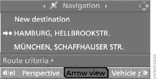
The arrow view appears on the screen.

1 Switching voice guidance on/off
2 Viewing traffic information
3 Selecting route criteria
4 Switching destination guidance on/off
5 Direction to destination in a straight line
6 Distance to next turn
7 Current location
8 Direction of travel
► Outline arrow: destination guidance along the calculated route
► Solid arrow:
shows the direction of the calculated route in a straight line when the vehicle is in an area not covered by the navigation DVD (e.g., in a car park).
The estimated time of arrival and the distance to the destination are shown in the upper or lower line of the control display (depending on equipment).
Before a turn, the arrow view changes.
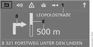
1 Name of street/road to turn onto
2 Distance to turn
3 Turn
To exit the menu, select and press the controller.
Activating the route map
You can follow your current location on the map. After destination guidance is started, the planned route is shown on the map.
1. Select "Navigation" and press the controller.
2. Move to the fourth field from the top.
Turn the controller to select the map display mode:
► “Map north-oriented”
► “Map, indicating dir. of travel”
► “Perspective”
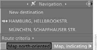
3. Press the controller.
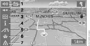
1 Switching voice guidance on/off
2 Switching destination guidance on/off
3 Selecting destination on map
4 Displaying the menu with the last selected information, see Selecting destination via additional information
5 Changing map display mode
►  „Map north-oriented“ ►
 „Map, indicating dir. of travel“ ►
 „Perspective“
6 Changing route criteria
7 Viewing traffic information
8 Direction to destination in a straight line
The bottom line of the control display shows the estimated time of arrival and the distance to the destination.
To exit the menu, select and press the controller.
At a scale of less than 500 km, you can select the map orientation: "North up", "Direction of travel" or "Perspective". At a scale of 500 km or more, the map is always oriented north up.
Changing the map display mode


Select the corresponding symbol and press the controller.
The map changes its view.
Changing the scale
The scale is changed by turning the controller.
Displaying towns and roads along the route
During route guidance, you can display a list of towns and roads along the route.
The remaining distance on individual roads is displayed at the same time.
1. Select “Navigation” and press the controller.
2. Move to the third field from the top.
Turn the controller to select "Route list" and press the controller.
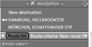
Traffic jam messages and arrow indicators are also shown on the display.
To exit the menu, select and press the controller.
Test yourself
A quick BMW X3 quiz: every answer comes with an explanation and a link to the manual page.