Displaying traffic information on the route map
Traffic information symbols appear on the route map at a scale of 200 km or less.
Sections with traffic information are highlighted, and the symbols described below are shown indicating the type of traffic event. This function depends on the selected map scale.
Displaying detailed information
Select the message in the list and press the controller.
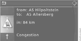
To exit the menu, select and press the controller.
Traffic information symbols
 With Navigation system Professional:
Traffic event – on the map at a scale of more than 10 km, an arrow indicates the corresponding direction.
 Several traffic events (displayed individually at smaller scales)
 Traffic light not working
 Road works
 Other obstructions
 Hazardous goods
 Vehicle in oncoming lane
 Height restriction
 No parking spaces
 Fog
 Heavy rain
 Risk of skidding
 Crosswind
 Smog
 Road closed
 Risk of traffic jam
 Stop-and-go traffic
 Traffic jam
 Black ice
 Uneven road
 Accident
 Road narrowing
 Delay
 Road check
 Slow traffic
 Stop-and-go traffic
 Traffic jam
 Road event in both directions
Test yourself
A quick BMW X3 quiz: every answer comes with an explanation and a link to the manual page.