Navigation - guidance
SELECTING A DESTINATION
The “NAVIGATION” voice commands are described in section 02.
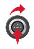
During guidance, a long press on the end of the lighting control repeats the last guidance instruction.
 Press the NAV key.

 The list of the last 20 destinations appears below the «Navigation» menu function.
 Press the NAV key again or select the «Navigation» menu function and press OK to confirm.


 Select the «Enter destination» function and press OK to confirm.


 Select the «Enter new address» function and press OK to confirm.


 Once the country is selected, turn the rotary control and select the city function. Press OK to confirm.

 Select the letters of the city one by one, pressing OK to confirm each time.

 A predefined list of cities in the selected country (by entering the first letters) is accessible from the LIST key on the virtual keyboard.
The map can be moved using the 4-way joystick. The orientation can be chosen from the «Full-screen map» shortcut menu. Press OK, then select «Map settings» and confirm.
 Turn the rotary control and select OK.
Press OK to confirm.

 For faster entry, you can enter the postcode directly after selecting the «Postcode» function.
Use the virtual keyboard to type the letters and numbers.
 Repeat steps 5 to 7 for the «Street» and «Number» functions.

 Select the «Add to address book» function to save the entered address in an entry of the directory. Press OK to confirm the selection.
NaviDrive 3D can store more than 4,000 contact records.
To delete a destination: from steps 1 to 3, select “From last destinations”.
A long press on one of the destinations displays a list of actions, from which you can choose:


 Then select «Start guidance» and press OK to confirm.


 Select the guidance criterion: «Fastest», «Shortest» or «Optimised time / distance» and press OK to confirm.

 Select the route with the colour corresponding to the chosen itinerary, press OK to confirm and start guidance.

 A destination can also be chosen «From address book» or «From last destinations», by selecting an intersection, a city centre, geographic coordinates, or directly on the «Map».


ASSIGNING AN ADDRESS AND NAVIGATING TO «HOME»
To be assigned to «Home», an address must first be saved in the address book, for example via «Enter destination» / «Enter new address» then «Add to address book».
1.  Press the NAV key twice to display the «Navigation» menu.


 Select «Enter destination» and confirm. Then select «From address book» and confirm.


 Select the home entry and confirm. Then select «Edit entry» and confirm.


 Select «Assign to «Home»» and confirm to save.


 To start guidance to «Home», press NAV twice to display the «Navigation» menu, select «Enter destination» and confirm.
Then select «Guide to «Home»» and confirm to start guidance.
GUIDANCE OPTIONS
When the map is displayed on screen, you can select «Map settings» then «Flat map / Perspective / 3D map / North up / Vehicle heading». Buildings visible in 3D depend on the progress of city mapping.
1.  Press the NAV key.

2.  Press the NAV key again or select the «Navigation» menu function and press OK to confirm.


3.  Select the «Guidance options» function and press OK to confirm.


4.  Select the «Guidance criteria» function and press OK to confirm. This function is used to change the guidance criteria.


5.  Select the «Traffic consideration» function.
This function gives access to the options «No detour», «With confirmation» and «Automatic».


6.  Select the «Exclusion criteria» function. This function gives access to the «Exclude» options (motorways, tolls, ferries, tunnels).


7.  Turn the rotary control and select the «Recalculate route» function to take the chosen guidance options into account. Press OK to confirm.


ADDING A STOP
1.  Press the NAV key.

2.  Press the NAV key again or select the «Navigation» menu function and press OK to confirm.


3.  Select the «Stops» function and press OK to confirm.


4.  Select the «Add stop» function (5 stops maximum) and press OK to confirm.


5.  Enter a new address, for example.


6.  Once the new address is entered, select «Start guidance» and press OK to confirm.


7.  Position the stop in the list and press OK to confirm.
 Repeat operations 1 to 7 as many times as necessary, then select «Recalculate route» and press OK to confirm.
8. Repeat steps 1 to 7 as many times as necessary, then select «Recalculate route» and press OK to confirm.
 To modify the stops, repeat operations 1 to 3 and select «Optimise route» (select a stop, delete it or move it in the list using the rotary control to change the order, confirm its new position and finish with «Recalculate route»).
SEARCHING FOR POINTS OF INTEREST (POI)
Points of interest (POI) show all nearby service locations (hotels, various shops, airports, etc.).
1.  Press the NAV key.

2.  Press the NAV key again or select the «Navigation» menu function and press OK to confirm.


3.  Select the «Search points of interest» function and press OK to confirm.


4.  Select the «Nearby» function to search for POI around the vehicle.


5.  Select the «Near destination» function to search for POI close to the route's destination.


6 Select the «In a city» function to search for POI in the desired city. Choose the country, then enter the city name using the virtual keyboard.


 A list of cities in the selected country is accessible from the LIST key on the virtual keyboard.
7.  Select the «In a country» function to search for POI in the desired country.


8.  Select the «Along the route» function to search for POI near the route.


CITROËN SEND-TO-CAR with
Find your destinations on Google Maps, then let CITROËN guide you.
REGISTRATION AND ACTIVATION
! This service only works with a SIM card from a French, German or Italian operator.
! The SIM card must be inserted into the holder located in the glovebox. The system does not work with a Bluetooth connection.
! SIM cards whose number has been transferred to another operator are not compatible with this service.
- To access the registration site, go to www.citroen.fr then activate the account with the registration confirmation e-mail.
- Register the vehicle and choose the identifier, which will be used to send POIs from Google Maps.
- Activate the service on your NaviDrive 3D according to the user guide downloaded from the website.
The Google Maps menu may take a few minutes to appear.
! For activation, the SIM card used must be the one declared on the website during registration.
Once activation is complete, you can change the SIM card or the operator.
USE
- Search for a POI on http://maps.google.fr. Select it and click «send».
Select «vehicle» and «CITROËN», then enter the chosen identifier. Click «send».
! Only Google Maps results marked with a red icon can be sent to the NaviDrive 3D system.
The “Notes” field is not sent.
 Press this key, then select Google Maps and confirm by pressing OK.
An automatic call is placed to a voicemail system to receive the POI.
- Press «ADDR BOOK» and select «My addresses» to display the list of received POIs.
You can then start guidance, call the POI or view it on the map.
! This service is free of charge, excluding communication costs - 2 SMS messages and 1 call for activation, 1 call for each POI reception (approximately 30 seconds).
 This icon appears when several POIs are grouped in the same area. Zoom in on this icon to view the POIs in detail.
LIST OF MAIN POINTS OF INTEREST (POI)
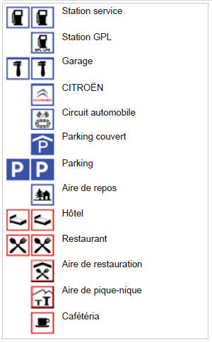
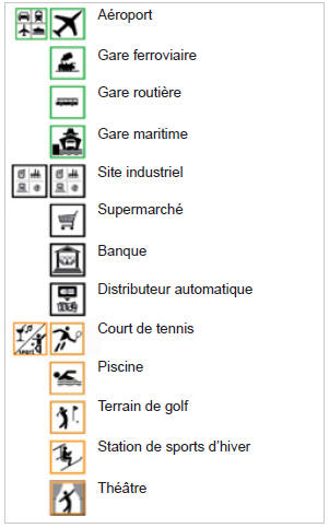
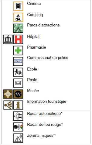
* Depending on country availability.
UPDATING POI RISK ZONES
! The detailed procedure for updating POI Risk Zones is available from the CITROËN network.
VOICE GUIDANCE OUTPUT SETTINGS
1.  When navigation is displayed on screen, press OK, then select or deselect “Voice message” to enable or disable the spoken guidance instructions.
Use the volume key to adjust the level.

! The volume of POI Risk Zone alerts can only be adjusted while this type of alert is being played.
POINTS OF INTEREST AND RISK ZONE SETTINGS
1.  Press the NAV key.

2.  Press the NAV key again or select the «Navigation» menu function and press OK to confirm.


3.  Select the “Settings” function and press OK to confirm.


4.  Select the “Points of interest on map” function to choose the POIs to display on the map by default.


5.  Select “Set up risk zones” to access the “Display on map”, “Visual alert on approach” and “Audible alert on approach” functions.


Test yourself
A quick Citroen C5 Aircross quiz: every answer comes with an explanation and a link to the manual page.