AVN System
Components and Component Location
Component Location
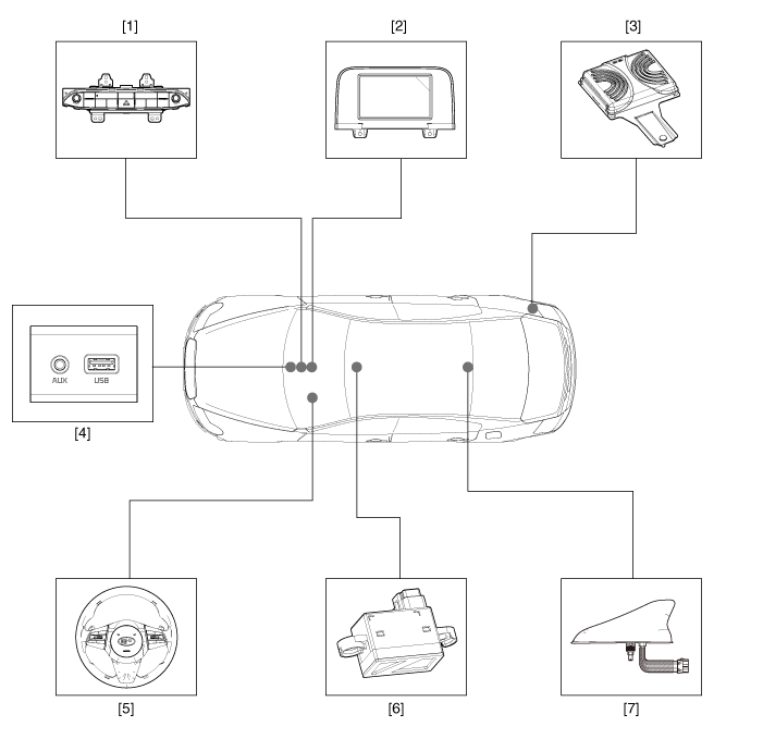
| 1. AVN Head Unit 2. Front AVN Monitor 3. External Amplifier 4. Multimedia Connector |
5. Steering Wheel Remote Control (SWRC) 6. Hands-Free Microphone 7. Roof Antenna (Radio + GPS + DAB) |
Description and Operation
Description
AVN system
The AVN system simplifies system operation, integrates vehicle information, and displays user information, improving information retrieval and user experience.
The system mainly consists of a combination function control keypad, LCD monitor, Bluetooth hands-free head unit, voice recognition and navigation, audio amplifier, and media unit that connects to other external devices.
Simplified User Interface: Multimedia and vehicle information are displayed on the monitor.
Networked Electronic Components: Efficient information transmission via CAN communication.
Integrated Advanced Technologies:
Voice recognition: This function recognizes the user's voice commands to control the system. The user can give voice commands to control the AV system, Bluetooth phone, and navigation.
Bluetooth hands-free: This complies with international wireless communication standards and uses Bluetooth technology adopted in most mobile phones currently on the market. Once paired, the driver's phone connects automatically each time the driver gets into the vehicle.
USB connection: External music players, such as a USB memory card or MP3 player, can be connected and played through the vehicle speakers.
System Block Diagram
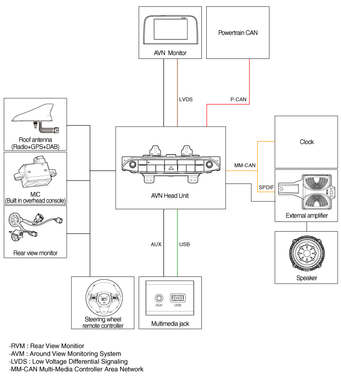
B-CAN: Body Controller Network
MM-CAN: Multimedia Controller Local Network
Navigation System Limitations
GPS Signal Reception Status
Because GPS satellite signals are received and transmitted along straight lines, reception may not work if an object is on or near the GPS antenna, or while driving in the following environments:
Tunnels
Underground parking structures
Under elevated roads
Roads through forested areas
Areas near high-rise buildings
Canyon roads
Vehicle Position Display
If multipath errors occur due to reflections from buildings or related causes, the current position mark on the navigation screen may differ from the actual vehicle position.
The vehicle position on the navigation system may differ from the actual position if the vehicle is in the following locations or driving conditions. In this case, drive for a short period to automatically correct the vehicle location according to map matching or GPS information. (This may take several minutes in some cases.)
When driving on a steep Y-shaped road, the current position may be displayed in the opposite direction.
If the vehicle is loaded onto a car carrier, the current position mark may stop at the last position before loading.
When driving on a spiral road.
When driving in mountainous areas with sharp curves or sudden braking.
When entering a road after leaving an underground parking structure, building parking structure, or multi-level turntable.
When the tires have been recently replaced (especially after using temporary spare or non-studded tires).
If the battery terminal has been disconnected.
When driving on city streets, the current position may be displayed on the opposite side of the road or in an off-road position.
When changing the scale from the maximum scale to another scale, the current position marker may be displayed on a different road.
When driving in heavy traffic with frequent stops or intersections.
When driving on slippery roads, such as deep sand or snow, etc.
When driving with snow chains installed.
When using tires of an incorrect size.
When the tire pressure of all 4 tires is different from each other.
When a replacement tire is worn or a used tire (especially a non-studded tire in its second season, etc.).
When driving near high-rise buildings.
If a roof rack is installed.
When driving at high speed or after calculating a long-distance route.
Route Guidance
Proper route guidance may not be provided due to search conditions or the driver's position.
On a straight road, a straight-ahead instruction may be given.
Guidance may not be given immediately after turning at an intersection.
Proper guidance may not be given at certain intersections.
Route guidance may indicate entry into a restricted area (No Entry, road under construction, etc.).
Guidance may be given to a location near the actual destination if roads to the actual destination do not exist or are too narrow.
Incorrect voice guidance may be given if the vehicle deviates from the set route (for example, if it turns at an intersection where navigation indicates to go straight).
Route guidance may not be provided if map data is missing or incorrect.
Route Recalculation
The following phenomena may occur after route recalculation.
Guidance may be given to a position different from the current position if the vehicle turned at an intersection.
Route recalculation may take longer when driving at high speed.
A route guidance signal for a U-turn may appear in an area where U-turns are prohibited.
In some cases, route guidance may indicate to the driver that entry is prohibited to a restricted area (Restricted Area, road under construction, etc.).
Guidance may be given to a location near the actual destination if roads to the actual destination do not exist or are too narrow.
Incorrect voice guidance may be given if the vehicle deviates from the set route (for example, if it turns at an intersection where navigation indicates to go straight).
Test yourself
A quick Kia Stinger CK quiz: every answer comes with an explanation and a link to the manual page.