System Description
SYSTEM DESCRIPTION
GENERAL DESCRIPTION OF NAVIGATION SYSTEM
(a) Vehicle position tracking methods
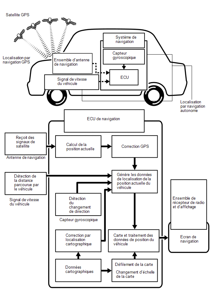
It is essential that the navigation system constantly locates the vehicle and shows its position on the map. There are 2 methods to determine the current position of the vehicle: autonomous navigation (estimation) and GPS* (satellite) navigation. Both navigation methods are used together.
*: GPS (Global Positioning System)
Operation | Description |
|---|---|
Calculating vehicle position |
The navigation ECU calculates the current position of the vehicle (direction and current location) using the yaw rate signal output by the gyro sensor and the travel distance signal output by the vehicle speed sensor, then determines the driving route. |
Map display processing |
The navigation ECU processes the vehicle position data, vehicle travel path and map data supplied from the internal memory. |
Map matching |
The map data supplied from the internal memory is compared with the vehicle position data and tracked travel path. The vehicle position is then matched to the nearest road. |
GPS Correction |
The vehicle position is matched to the position measured by the GPS. Then, the position data measured by the GPS is compared with the vehicle position and the travel track data. If the position is significantly different, the position measured by the GPS is used. |
Distance Correction |
The vehicle speed signal may contain errors due to tire wear and poor tire grip on the road. Distance correction takes these errors into account. The navigation ECU automatically compensates for the difference between the distance signal and the distance data on the map. The compensation is updated automatically. |
HINT:
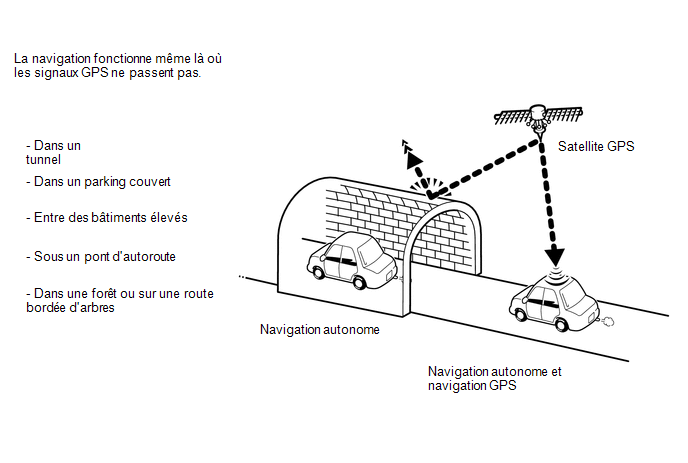
Combined dead reckoning and GPS navigation allow the vehicle position to be displayed even in areas where GPS signals cannot be received. However, when only the dead reckoning navigation system is used, the position may be slightly less accurate.
(b) Dead Reckoning Navigation
This method determines the relative position of the vehicle based on the driving path detected by the gyro sensor in the navigation ECU and the vehicle speed signal.
(1) Gyro Sensor
Calculates the direction by detecting the angular velocity. It is located in the navigation ECU.
(2) Vehicle Speed Signal
Used to calculate the distance traveled by the vehicle.
(c) GPS* (Global Positioning System) Navigation
This method detects the absolute position of the vehicle using radio waves from GPS satellites.
*: GPS satellites were launched by the United States Department of Defense for military purposes.
Number of Satellites | Measurement | Description |
|---|---|---|
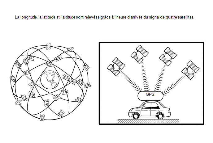
2 maximum |
Measurement not possible |
The vehicle position cannot be determined due to an insufficient number of satellites. |
3 |
2-dimensional measurement is possible. |
The vehicle position is calculated based on longitude and latitude. (This result is less accurate than 3-dimensional measurement.) |
4 |
3-dimensional measurement is possible. |
The vehicle position is calculated based on longitude, latitude and altitude. |
(d) Map Matching
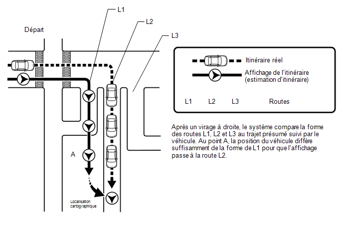
The route traveled by the vehicle is calculated by the dead reckoning navigation system (using the gyro sensor and the vehicle speed signal) and the GPS navigation system. This information is then compared with the road shapes stored in the internal memory map data, and the vehicle position is matched to the best-fitting road.
USB AUDIO SYSTEM FUNCTION DESCRIPTION
(a) The audio system AUX adapter kit is equipped with a USB connector. Connecting a USB device or "iPod" to the audio system AUX adapter kit allows music files to be played. In addition to playing music from a USB device with audio functions, MP3, WMA, AAC, WAV (LPCM), FLAC, ALAC or OGG Vorbis files stored on a USB device can also be played. The "iPod" software is also installed, which allows files to be selected from playlists and the shuffle play mode to be used.
HINT:
Operations using the controls of a connected USB device or "iPod" cannot be performed while it is connected.
(b) USB Audio System Compatible Devices
(1) USB Device
The following device formats can be used:
Compatible USB Device Formats |
|
MP3, WMA, AAC, WAV (LPCM), FLAC, ALAC or OGG Vorbis files stored on a USB device in a format other than those listed above may not be played correctly, and their file names and folder names may not be displayed correctly.
The standards and limitations are as follows:
- Maximum directory tree depth: 8 levels
- Maximum number of folders on the device: 3000 (including the root folder)
- Maximum number of files on the device: 9999
- Maximum number of files per folder: 255
(2) "iPod"
"iPhone", "iPod", "iPod classic", "iPod nano" and "iPod touch" are trademarks of Apple Inc., registered in the U.S. and other countries.
"iPod", "iPod nano", "iPod classic", "iPod touch" and "iPhone" devices can be used with this system.
- "iPod touch" (6th generation)
- "iPod touch" (5th generation)
- "iPod nano" (7th generation)
- "iPhone 7 plus"
- "iPhone 7"
- "iPhone SE"
- "iPhone 6s plus"
- "iPhone 6s"
- "iPhone 6 plus"
- "iPhone 6"
- "iPhone 5s"
- "iPhone 5c"
- "iPhone 5"
- "iPhone 4s"
HINT:
- Depending on differences between models or software versions, some models may not be compatible with this system.
- "iPod video" is not supported.
USB VIDEO SYSTEM FUNCTION DESCRIPTION
(a) Video file standards that can be played
File format |
MPEG-4, AVI Container, Windows Media Video |
Corresponding Screen Size |
MAX 1,920 x 1,080 |
Corresponding Frame Rate |
MAX 60i/30p |
HIGH-RESOLUTION AUDIO SOURCE FUNCTION DESCRIPTION
(a) This unit supports high-resolution audio sources.
(b) The definition of high resolution is based on standards set by groups such as the CTA (Consumer Technology Association).
(c) The following formats and media can be used:
Supported formats |
WAV (LPCM), FLAC, ALAC, OGG Vorbis |
Usable media |
USB |
DESCRIPTION OF FILE INFORMATION
(a) Playable MP3 file standards
Compatible standard |
MPEG1 LAYER3, MPEG2 LSF LAYER3 |
Compatible sampling rate |
|
Compatible bit rate |
|
Compatible channel mode |
Stereo, joint stereo, dual channel, mono |
(b) Playable WMA file standards
Compatible standard |
WMA version 7, 8 and 9 |
Compatible sampling rate |
32, 44.1, 48 (kHz) |
Compatible bit rate (compatible with dual channel playback only) |
|
(c) Playable AAC file standards
Compatible standard |
MPEG4/AAC-LC |
Compatible sampling rate |
11.025, 12, 16, 22.05, 24, 32, 44.1, 48 (kHz) |
Compatible bit rate |
|
(d) Usable WAV (LPCM) file standards*
| *: Files with a sampling rate higher than 48 kHz are converted to 48 kHz/24 bit. | |
Compatible sampling rate |
8/11.025/12/16/22.05/24/32/44.1/48/88.2/96/176.4/192 (kHz) |
Compatible bit rate |
16/24 (bit) |
(e) Usable FLAC file standards*
| *: Files with a sampling rate higher than 48 kHz are converted to 48 kHz/24 bit. | |
Compatible sampling rate |
8/11.025/12/16/22.05/24/32/44.1/48/88.2/96/176.4/192 (kHz) |
Compatible bit rate |
16/24 (bit) |
(f) Usable ALAC file standards*
| *: Files with a sampling rate higher than 48 kHz are converted to 48 kHz/24 bit. | |
Compatible sampling rate |
8/11.025/12/16/22.05/24/32/44.1/48/64/88.2/96 (kHz) |
Compatible bit rate |
16/24 (bit) |
(g) Usable OGG Vorbis file standards*
| *: Files with a sampling rate higher than 48 kHz are converted to 48 kHz/24 bit. | |
Compatible sampling rate |
8/11.025/16/22.05/32/44.1/48 (kHz) |
Compatible bit rate |
|
(h) ID3 tag, WMA tag, AAC tag, TAG and Vorbis comment
(1) Additional text information, called ID3 tags, can be entered into MP3 files. Information such as song titles and artist names can be stored.
HINT:
This player is compatible with ID3 tags of ID3 versions 1.0 and 1.1, and ID3 Ver. 2.2 and 2.3. (Number of characters conforms to ID3 versions 1.0 and 1.1, and ID3 Ver. 2.2 and 2.3.)
(2) Additional text information, called WMA tags, can be entered into WMA files. Information such as song titles and artist names can be stored.
(3) Additional text information, called AAC tags, can be entered into AAC files. Information such as song titles and artist names can be stored.
(4) Additional text information called TAGs can be entered into WAV (LPCM), FLAC and ALAC files. Information such as song titles and artist names can be stored.
(5) Additional text information called Vorbis comments can be entered into OGG Vorbis files. Information such as song titles and artist names can be stored.
(i) Usable media
(1) USB devices can be used to play MP3/WMA/AAC/WAV (LPCM)/FLAC/ALAC/OGG Vorbis files.
(j) Usable media format
(1) Standards and restrictions
Maximum folder levels |
8 levels |
Maximum number of characters for a folder/file name |
32 characters |
Maximum number of folders |
192 (including empty folders, root folders and folders not containing MP3/WMA/AAC files) |
Maximum number of files on a disc |
255 (including non-MP3/WMA/AAC files) |
(k) File names
(1) Only files with the extension ".mp3", ".wma", ".m4a", ".wav", ".flac", ".alac", ".ogg" and ".oga" can be recognized and played as MP3, WMA, AAC, WAV (LPCM), FLAC, ALAC or OGG Vorbis files.
(2) Save MP3, WMA, AAC, WAV (LPCM), FLAC, ALAC or OGG Vorbis files with the extension ".mp3", ".wma", ".m4a", ".wav", ".flac", ".alac", ".ogg" or ".oga".
NOTICE:
If files other than MP3, WMA, AAC, WAV (LPCM), FLAC, ALAC or OGG Vorbis files are saved with the extension ".mp3", ".wma", ".m4a", ".wav", ".flac", ".alac", ".ogg" or ".oga", these files may be incorrectly recognized as MP3, WMA, AAC, WAV (LPCM), FLAC, ALAC or OGG Vorbis files and played incorrectly. In this case, loud noise may occur and the speakers may be damaged.
GENERAL DESCRIPTION OF "Bluetooth" TECHNOLOGY
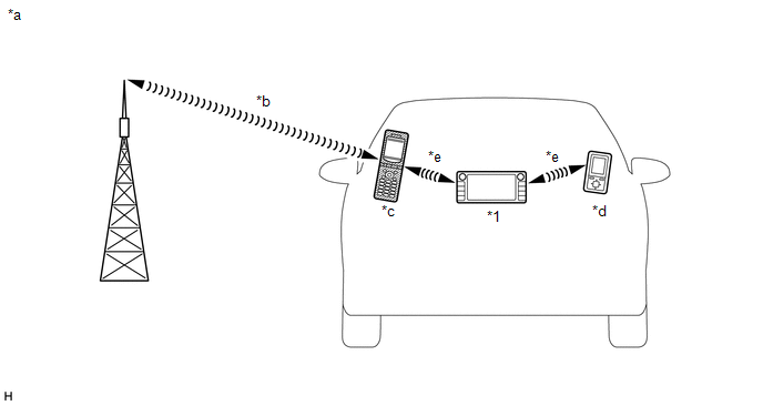
*1 |
Radio and Display Receiver Assembly (Built-in "Bluetooth" antenna) |
- |
- |
*a |
Example |
*b |
Mobile network |
*c |
Mobile phone (Bluetooth compatible) |
*d |
Bluetooth compatible (Bluetooth compatible) |
*e |
Bluetooth wireless connection |
- |
- |
(a) "Bluetooth" is a registered trademark owned by Bluetooth SIG, Inc.
(b) "Bluetooth" is a wireless connection technology that uses the 2.4 GHz frequency band.
HINT:
Communication performance of "Bluetooth" technology varies depending on obstacles or conditions in which radio waves travel between communication devices, electromagnetic waves, the sensitivity of the communication devices, or the capacity of the antenna.
(c) Hands-free function
(1) The built-in "Bluetooth" radio receiver and display unit and a "Bluetooth" compatible mobile phone* can be connected using a "Bluetooth" wireless connection. This feature allows you to use the hands-free function of the mobile phone even if the phone is in a pocket or bag. Therefore, no connector or cable is needed to connect the mobile phone.
*: Some versions of "Bluetooth" compatible mobile phones may not operate correctly.
(2) The hands-free function uses a "Bluetooth" wireless connection. A "Bluetooth" wireless connection can be affected by factors with uncertain effects, such as the vehicle location, time of day, etc. Therefore, connection problems may temporarily be caused by "Bluetooth" connection conditions. When performing diagnostic procedures, it is necessary to check the transmission frequency, the connection status using another mobile phone, etc.
(3) Compatible hands-free devices
Required "Bluetooth" specifications |
Ver. 2.0 or later (Ver. 4.1+EDR recommended) |
Supported profiles |
|
Maximum number of hands-free devices that can be registered (including audio devices) |
5 |
- *1: This profile is required when using the hands-free function.
- *2: This profile is required when using the Toyota Entune function.
- *3: This profile is required when using the message function (with SMS/MMS/e-mail function).
HINT:
- Mobile phones compatible with "Bluetooth" technology can be checked at http://www.toyota.com/entune/.
- The remaining battery charge level displayed on the radio and display receiver assembly may differ from that of the "Bluetooth" device.
(d) "Bluetooth" audio function
(1) The radio and display receiver assembly with built-in "Bluetooth" and a "Bluetooth"-compatible portable audio player* can be connected via a wireless "Bluetooth" connection. Files stored on the portable audio player can thus be played through the vehicle speakers. In addition, functions such as play/stop can be operated directly from the radio and display receiver assembly.
*: Some versions of "Bluetooth"-compatible audio players may not connect via "Bluetooth", or music may play but the functions accessible through the audio system may be limited.
(2) "Bluetooth"-compatible audio devices
Required "Bluetooth" specifications |
Ver. 2.0 or later (Ver. 4.1+EDR recommended) |
Supported profiles |
|
Maximum number of audio devices that can be registered (including hands-free devices) |
5 |
RADIO DESCRIPTION
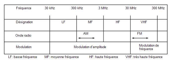
(a) Radio frequency band
(1) Radio broadcasts use the frequency bands shown in the table below.
(b) Reception area
(1) The reception areas for AM and FM broadcasts differ greatly. Sometimes an AM broadcast can be received much more clearly than a stereo FM broadcast. Stereo FM has the smallest reception area and tends to pick up static and other interference such as noise.
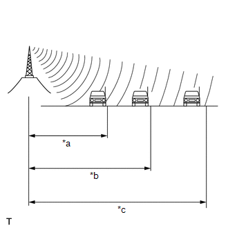
*a |
FM (stereo) |
*b |
FM (mono) |
*c |
AM |
(c) Radio reception problems
HINT:
In addition to static interference, other problems exist such as "phasing", "multipath interference" and "signal fading". These problems are not caused by electrical noise but by the very method of radio signal propagation.
(1) Phasing
AM broadcasts are subject to electrical interference and to another type of interference called "phasing". Occurring only at night, phasing is interference created when a vehicle receives 2 radio wave signals from the same transmitter. One of the signals is reflected by the ionosphere and the other is received directly from the transmitter.
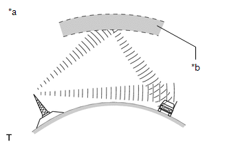
*a |
Phasing |
*b |
Ionosphere |
(2) Multipath interference
Multipath interference occurs when a vehicle receives 2 radio wave signals from the same transmitter. One of the signals is reflected by buildings or mountains and the other is received directly from the transmitter.
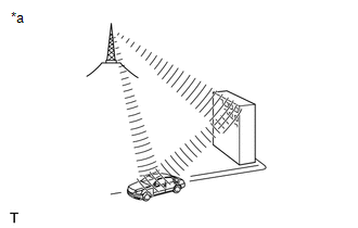
*a |
Multipath interference |
(3) Signal fading
Signal fading is caused by obstacles (buildings, mountains or other large obstructions) that deflect part of the signal, resulting in a drop in signal strength when the obstacle is between the transmitter and the vehicle. High-frequency radio waves, such as FM broadcasts, are easily deflected by obstacles. Low-frequency radio waves, such as AM broadcasts, are less likely to be deflected.
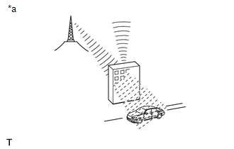
*a |
Signal fading |
(d) Noise problems
Technicians must pay particular attention to noise problems reported by the customer. Use the following table to diagnose noise problems.
Radio frequency | Noise occurrence condition | Probable cause |
|---|---|---|
AM |
Noise occurs at certain locations |
External noise |
Noise occurs when listening to an intermittent broadcast |
The same program broadcast from several transmitters may cause noise when the signals interfere with each other |
|
Noise occurs only at night |
Signal phasing |
|
FM |
Noise occurs at certain locations while driving |
Multipath interference resulting from an FM frequency change |
GENERAL DESCRIPTION OF THE HD "RADIO" FUNCTION
(a) The "HD Radio" system is a radio system that broadcasts in IBOC (In-Band On-Channel) format, developed by iBiquity Co. By widening the bandwidth per channel of conventional FM/AM bands, digital audio and data signals are transmitted simultaneously.
"HD Radio" technology is manufactured under license from iBiquity Digital Corporation. U.S. and foreign patents. "HD Radio", and the HD and HD Radio logos are trademarks owned by iBiquity Digital Corporation. Traffic and weather information displayed on the navigation screen can also be received.
GENERAL DESCRIPTION OF THE SIRIUSXM FUNCTION
(a) SiriusXM (SXM) Satellite Radio is a digital satellite radio broadcast offered by SiriusXM Radio Inc. The subscription-based broadcast is transmitted via satellites and terrestrial repeater networks. Several unique channels are available, and the same information can be received without interruption even while the vehicle is moving. Information such as song titles and station names can be received.
NOTICE:
To receive subscription-based broadcasts, the customer must sign a subscription contract with SiriusXM Satellite Radio Inc. After the contract is signed, the Radio ID must be registered. In addition, if any parts are replaced, the Radio ID must be registered again.
HINT:
When the cable is disconnected from the negative (-) battery terminal, the radio station logo data will be initialized. It takes some time for the broadcast station logo data to be updated.
GENERAL DESCRIPTION OF VEHICLE CUSTOMIZATION
(a) Function customization can also be performed on the multi-information display. Refer to the Owner's Manual for more information on the navigation system items that can be customized.
HINT:
- Items available through the navigation system can be customized using the Techstream.
- Some customization settings displayed on the Techstream will appear on the vehicle's navigation system customization screen. Users can customize these items.
DESCRIPTION OF ASL (AUTOMATIC SOUND LEVELIZER) FUNCTION
(a) The Automatic Sound Levelizer (ASL) function automatically adjusts the audio system volume to compensate for increasing vehicle noise (vehicle noise tends to increase as vehicle speed increases). The Automatic Sound Levelizer adjusts the volume based on the vehicle speed signals transmitted from the combination meter assembly.
GENERAL DESCRIPTION OF THE DYNAMIC VOICE RECOGNITION FUNCTION
(a) There are two types of voice recognition. The voice recognition function uses voice recognition data stored in the onboard device. The other is communication-based and uses voice recognition data sent to the center via the DCM (Data Communication Module) as audio signals through communication.
HINT:
Refer to the TOYOTA ENTUNE SYSTEM for more information about communication-based voice recognition.
Click here
GENERAL DESCRIPTION OF THE MOBILE ASSISTANT FUNCTION
(a) With a compatible mobile device connected via "Bluetooth", this function allows direct operation of the interface system for voice recognition functions. The steering wheel switch is operated to start the mobile assistant function, and the function is then operated using voice commands.
HINT:
The mobile assistant may not function or the device may not respond depending on the type of connected device, the OS version (iOS/Android) or the Google app version.
GENERAL DESCRIPTION OF THE "Wi-Fi" HOTSPOT
HINT:
- To use the "Wi-Fi" hotspot function, the initial setup of the Toyota Entune App Suite function must be performed.
- To perform the initial setup, go to http://www.toyota.com/entune/.
(a) "Wi-Fi" is a widely used global wireless communication standard for short-range communication.
(b) "Wi-Fi" is a registered trademark of the Wi-Fi Alliance, a non-profit industry association.
(c) The radio and display assembly uses the 2.4 GHz frequency band for "Wi-Fi" communication.
HINT:
The "Wi-Fi" communication performance varies depending on obstacles or conditions between the communication devices, radio wave propagation, the sensitivity of the communication devices, or the antenna capability.
GENERAL DESCRIPTION OF APP LINK FUNCTION
(a) The App Link function allows the main unit to use smartphone applications by connecting the smartphone to the main unit with a dedicated cable.
HINT:
Some applications have display restrictions to ensure safe driving.
COMMUNICATION SYSTEM
(a) General Description of Local Bus Communication
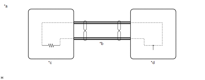
*a |
Example |
*b |
Local Bus Communication Line |
*c |
Main Unit |
*d |
Sub Unit |
(1) The components of the navigation system communicate with each other via the local bus.
(2) The local bus uses a twisted wire pair for its communication lines.
(3) The main unit of the local bus is the radio and display receiver assembly.
HINT:
- The radio and display receiver assembly has the resistance (108 to 132 Ω) required for communication.
- If there is an open or short circuit in the local bus circuit, communication is interrupted and the system does not operate normally.
(b) CAN Communication System Description
(1) The navigation system uses CAN communication between the radio and display receiver assembly and the ECUs.
GENERAL DESCRIPTION OF DIAGNOSTIC FUNCTION
(a) The navigation system has a diagnostic function (the result is displayed on the main unit).